NOAA launches drones to sail the West Coast, survey anchovies, sardines and other fish
 (Photo: Courtesy of John Gussman)
A bright orange and yellow drone boat will set sail in August, skimming down the West Coast as it collects data on fish and possibly changes the way experts study the ocean.
It’s one of five on a summer-long expedition to test the drones’ accuracy in assessing West Coast fish stocks. Those surveys help set limits on just how much fish can be caught each year.
“You want to use the best available science to come up with the best estimate of what the stock is, so that you can give a fair shake to the fishermen,” said Toby Garfield, director of environmental research division at Southwest Fisheries Science Center.
Typically, the surveys are done by ship. But the National Oceanic and Atmospheric Administration teamed up with Oceans Canada and Saildrone Inc. to test out the drones.
This is one alternative to collecting the data – one that may be able to go places ships can’t or to better estimate how many fish are out there, Garfield said.
Satellite imagery changed the way researchers looked at the ocean, he said, and “tools like Saildrone will give us another way to actually sample” it.
Two drones were launched last week from Neah Bay, Washington, and a second pair will be launched shortly. All four of those will follow the route of the NOAA ship Reuben Lasker.
Operators control the unmanned watercraft remotely from Saildrone’s headquarters in Alameda, California. Plans call for the drones to collect acoustic data on hake and pelagic fish, like sardines and anchovy, for up to 100 days.
 Five Saildrones will be launched on the West Coast this summer. (Photo: Courtesy of John Gussman)
“Our ship is out there now. It’s out doing an 80-day survey from Vancouver Island down to the Mexican border,” Garfield said. “The two pairs are going to replicate that tract.”
Researchers will then compare the ship’s information to what’s collected by the drones to see if the new technology could be used to replicate some of the ship’s surveys.
They already know there will be differences, including that the drones will move slowly, about 1 or 2 knots.
There’s also a chance the drones could come closer to shore than the ships, which could help expand the surveys. Whether that’s possible depends on a lot of variables from the abundance of kelp to the number of recreational boats on the water.
That’s where the fifth drone comes in.
“That’s the one we’re going to try to use to explore whether we can come farther into shore,” Garfield said.
They’ll also want to use that drone to test whether it could sail in front of the ship to pinpoint the best spots to sample and, if instead of chasing the fish, they could use the drone in one area to track them as they swim by.
The fifth drone is scheduled to launch off Alameda on Aug. 13 and will be sailing for about six months. But it may not reach Ventura County.
“Originally, we were going to have the Saildrone operate all the way down to San Diego,” Garfield said Tuesday.
But the company had concerns about the traffic in the Santa Barbara Channel, as well as light winds in the summertime.
They’re going to make a decision closer to the date of the launch, he said. “It’s really going to depend on conditions.”
To follow the drones’ progress, go to NOAA’s blog at https://www.nwfsc.noaa.gov/news/blogs.
Original post and video: https://www.vcstar.com/
Saildrone launch begins test to improve West Coast fisheries surveys
June 2018Contributed by Michael MilsteinTwo autonomous Saildrones launched from Neah Bay, Wash., Tuesday on a summer-long partnership between Saildrone Inc., NOAA Fisheries and Fisheries and Oceans Canada (DFO) to find out whether the wind and solar-powered vehicles can improve the efficiency and accuracy of fisheries surveys off the West Coast.The two Saildrones will first head to the northern end of Vancouver Island and will then turn south, following a series of transects along the Coast south to San Francisco. Two other Saildrones will join the project fleet next week from Alameda, Calif., following transects from San Francisco south to the Southern California Bight. (See map.) They will gather acoustic data on Pacific hake (whiting) and pelagic species such as sardines, anchovy and mackerel that make up many of the West Coast’s most important commercial fisheries. Fishermen unloaded 558 million pounds of hake worth about $47 million in ports such as Astoria, Ore., and Westport, Wash., in 2016.The NOAA ship Reuben Lasker will also follow the transects and gather similar acoustic data for comparison. The Lasker is specially equipped with advanced echosounders for accurately surveying fish populations.
 Technicians prepare the first two Saildrones for launch from Neah Bay, Wash. NOAA Fisheries/NWFSC
A fifth Saildrone launching from Alameda in August will test its value for conducting focused fisheries surveys, such gathering data in near-shore areas that large NOAA research ships cannot safely reach. The fifth vehicle will focus particularly on historically important areas for fisheries, such as Monterey Bay and off the San Francisco Bay Area.“This partnership is putting some of the most important new marine technology to work for the West Coast,” said Toby Garfield, Acting Deputy Director of NOAA Fisheries’ Southwest Fisheries Science Center in La Jolla, Calif., and part of the team directing the fifth Saildrone. “The more complete and accurate data we have, the better decisions our fisheries managers can make in real terms of catch levels and seasons.”The first two Saildrones left Neah Bay about 1 p.m. Tuesday. The vehicles were operating normally, scientists said, but must travel to Canadian waters before they begin collecting data on their transects heading south. The Saildrone team extended its thanks to the Makah Tribe, which authorized the launch from its marina in Neah Bay.The northernmost surveys are particularly important for hake, a deep-water fish that supports an international fishery that the United States and Canada manage jointly under the Pacific Whiting Treaty. DFO scientists are assisting in management of the mission.Please follow the progress of the West Coast Saildrone fisheries mission on the blog “Unmanned! Saildrone Expedition 2018.”NOAA Fisheries' Alaska Fisheries Science Center has been testing Saildrone technology, along with NOAA Research's Pacific Marine Environmental Laboratory in Alaska for the past three years to gather oceanographic data, acoustic data on endangered North Pacific right whales, information on walleye pollock, and for prey surveys within the foraging range of a declining population of northern fur seals. This year, the focus in Alaska will be on studying abundance and distribution of Arctic cod in the Chukchi Sea.The launch of Saildrones along the West Coast demonstrates NOAA Fisheries’ continued commitment to embrace new technologies to maximize efficiencies and advance its mission.
 Teams ready a Saildrone for launch from Neah Bay, Wash. NOAA Fisheries/NWFSC
Originally posted: https://www.nwfsc.noaa.gov/
Controversial drift-gill net fishery wins long-fought battle
Federal fishery managers denied a proposal this week to immediately shut down Southern California’s most controversial fishery in the event that wide-mesh gill nets accidentally kill a handful of certain marine mammals or sea turtle species.The swordfish and thresher shark fishery will remain open, even if it kills several whales or sea turtles, the NOAA’s National Marine Fisheries decided.The decision not to institute so-called hard caps on the fishery comes after a public review period initiated last year was extended to discuss the law proposed by the state’s Pacific Fishery Management Council in 2014.For the few dozen fishers who still catch swordfish and thresher sharks off Southern California in deep-water drift gill nets, the decision brought a big sigh of relief.“It’s a great feeling to know that NOAA is using science and not political pressure to decide this issue,” said longtime local fisherman David Haworth. “We have just a few people fighting against millions of environmentalists who think taking one of anything is too many: That would be great, but we have to feed the whole world.”The decision was a blow to Oceana, The Pew Charitable Trusts and other conservation groups that have lobbied for years to close the fishery.“We’re disappointed that NOAA Fisheries decided to abandon these plans. It’s a long time coming,” said Paul Shively, project director for The Pew Charitable Trusts. “We did a poll (in 2015) that showed overwhelming support with Californians to shut down the fishery.“This still remains the most harmful fishery on the West Coast when it comes to marine mammals and sea turtles.”
Existing protections working
The proposed hard caps would have forced a seasonal closure if gill nets killed two sea turtles or fin, humpback or sperm whales, or four short-fin pilot whales or bottlenose dolphin over a two-year period.In 2015, 18 drift gill net vessels landed 66 metric tons of swordfish worth $454,000, according to a report by NOAA — the National Oceanic and Atmospheric Administration. Meanwhile, the U.S. imported 8,386 metric tons of the fish from other countries.Fishers and National Marine Fisheries Service regulators say protections they’ve instituted since the mid-1990s, when drift gill nets were indiscriminately killing tons of marine animals, have come a long way.“We increased our net size and that helped (reduce bycatch) a lot,” Haworth said. “What’s very discouraging for us right now is that most marine mammal species are on the increase now. They wanted to shut us down over animals that are doing better. So, it was like, ‘What’s going on here?’ ”NOAA fishery biologist Jim Carretta, who specializes in creating marine mammal protections, said regulations implemented since the 1990s have greatly reduced gill net damage.Gill nets are now made with wider mesh to allow larger animals to escape, and are placed 36 feet below the ocean’s surface to avoid marine mammal interaction. They also have acoustic pingers that divert dolphins and other species.“If you have a bycatch problem, you don’t immediately shut down the entire fishery. You start examining what factors are driving the problem,” Carretta said. “We’ve had great success in reducing bycatch in this fishery. But it’s not going to go to zero.”Regulators and fishers are also testing new technologies to bring additional protections for bycatch, such as a new deep-set buoy gear and electronic observers on boats to monitor catches.State Sen. Ben Allen, whose district includes much of the South Bay coast, proposed a bill last year that would hasten the use of deep-set buoy gear and ban gill nets. It remains in committee.“We already have allowable take numbers for these marine mammals,” Carretta said. “The hard cap levels seemed arbitrary to me. They were not thoroughly steeped in the science behind calculating how much bycatch is sustainable.”The Marine Mammal Protection Act and the Endangered Species Act also continue to set protections for vulnerable marine animals that were hunted to near-extinction.
‘Redheaded stepchild of fishing’
Mike Conroy, president of West Coast Fisheries Consultants that represents fishers, said he believes the rule would have been overturned in the courts if it had passed.“Twenty years ago, the drift gill net fishery was the Wild West, but I can’t even remember the last time a turtle was caught,” Conroy said. “(The proposed rule) probably wasn’t enforceable anyway.”Gary Burke, a veteran drift gill net fisher, also said he hasn’t seen a sea turtle in years.But Shively questioned whether environmentalists can rely on the word of fishers whose livelihood depends on keeping the fishery opened. He advocates for having observers on board every fishing boat to ensure they’re accurately reporting bycatch. Regulators say that’s not feasible.“We’re been the redheaded stepchild of fishing,” Burke said. “All fisheries have bycatch. But we’ve done great jobs to limit what we can. We are going to have some, but the question is whether we’re killing too many. That’s why NOAA takes estimates and decides how many can be removed to maintain healthy populations.”
Originally posted: http://www.dailybreeze.com/
Two Decades Later, Focused Efforts on Reducing Entanglements in Gillnet Fishery Still Paying Off
June 2017In the early 1990s the drift gillnet fishery targeting swordfish off the U.S. West Coast took a high toll on whales, sea turtles and dolphins, with the drifting nets entangling and killing hundreds of these protected species each year. It was clear that management action was needed to reduce entanglements. 
Swordfish. Photo: copyright William Boyce
In 1996, NOAA Fisheries convened a “take reduction team,” under the Marine Mammal Protection Act. The team brought together scientists, fishermen, representatives of environmental organizations, and others to develop strategies that would reduce the entanglements. Those strategies included net modifications and sound-emitting devices.The recommendations of the Pacific Offshore Cetacean Take Reduction Team (POCTRT) quickly reduced entanglements, as documented by observers aboard fishing vessels in the late 90s. Today, some 25 years later, the drift gillnet fishery that catches swordfish, opah, and some sharks off the West Coast continues to have low impacts on protected species; it entangles very few whales, sea turtles, and dolphins.
Source: Carretta, J.V., J.E. Moore, and K.A. Forney. 2017. Regression tree and ratio estimates of marine mammal, sea turtle, and seabird bycatch in the California drift gillnet fishery: 1990-2015. NOAA Technical Memorandum, NOAA-TM-NMFS-SWFSC-568. 83p. Available online at https://swfsc.noaa.gov/publications/TM/SWFSC/NOAA-TM-NMFS-SWFSC-568.pdf

Source: Carretta, J.V., J.E. Moore, and K.A. Forney. 2017. Regression tree and ratio estimates of marine mammal, sea turtle, and seabird bycatch in the California drift gillnet fishery: 1990-2015. NOAA Technical Memorandum, NOAA-TM-NMFS-SWFSC-568. 83p. Available online at https://swfsc.noaa.gov/publications/TM/SWFSC/NOAA-TM-NMFS-SWFSC-568.pdf
“This fishery has made great improvements in the last two decades,” said Barry Thom, Regional Administrator of NOAA Fisheries’ West Coast Region. “If you look at the numbers of whales, turtles, and dolphins affected, they have all declined over the years and remain very low today.”For instance, the drift gillnet fishery killed or seriously injured almost 20 endangered leatherback turtles per year in some years in the early 1990s. Now leatherback deaths and injuries are rare, with an estimate of just one since 2009. An estimated 50 beaked whales were injured or killed in drift gillnets in some years in the early 1990s, but estimates now show just one seriously injured or killed since 2002.Humpback whales are among the most common whales off California but estimates show none have been killed or seriously injured in drift gillnets since 2008.Improvements in the fishery include pingers, which are devices that emit sounds to warn marine mammals away from the gillnets; and net extenders that lower the nets at least 36 feet beneath the surface, leaving room for surface-swimming animals such as dolphins to pass above them. In addition, the agency designated two large conservation areas off the West Coast that are off-limits to drift gillnets when endangered sea turtles are known to frequent the areas.
Above: A large area of ocean off the coast of California and Oregon is off limits to drift gillnet fishing each year to protect endangered leatherback sea turtles. Another area off southern California is closed during El Nino years (as determined by NOAA Fisheries) when water temperatures are warmer than average and loggerhead sea turtles are likely to be present.
The improvements have helped the drift gillnet fishery off the West Coast provide a local and sustainable domestic source of seafood with less environmental impact than many alternatives, including swordfish from some foreign fisheries that take a greater toll on marine mammals and sea turtles. After years of adaptive management to reduce the fishery’s impacts, the drift gillnet fishery now has impacts on protected species comparable to other U.S. fisheries, including the U.S. Atlantic swordfish longline fishery, which is certified by the Marine Stewardship Council.Improvements in the fishery have been recognized by others, including the Monterey Bay Aquarium’s Seafood Watch Program that considers swordfish and most other species caught with drift gillnets on the West Coast a “good alternative” for consumers.“Although sea turtle interactions used to be an issue in this fishery, management measures put into place in 2001 have greatly reduced these incidental encounters,” Seafood Watch said in a recent update of its ratings for swordfish from the West Coast drift gillnet fishery.While the improvements have been substantial, fishery managers continue to look for additional ways to harvest swordfish with even less impact. The Pacific Fishery Management Council and NOAA Fisheries have encouraged research into new fishing methods such as deep-set buoy gear, which in early trials has proven to catch swordfish with almost no bycatch of non-marketable fish or impacts on protected species.NOAA Fisheries is also collaborating with industry and co-managers on the West Coast to reduce impacts of other fisheries on large whales off the West Coast.“We’re always looking for opportunities to reduce impacts on whales, sea turtles, and other protected species,” said Chris Yates, Assistant Administrator for Protected Species in NOAA Fisheries’ West Coast Region. “Fortunately we have built good partnerships, and we’ve made substantial progress.”LEARN MORE about the fishery and recent management actionsLEARN MORE about North Pacific swordfish harvest and sustainability at FishWatchWATCH a short movie about efforts in West Coast fisheries to protect sea turtles and marine mammals
Read the original post: http://www.westcoast.fisheries.noaa.gov/
Status of Stocks 2015: U.S. Fisheries Continue to Rebuild

April 20, 2016
NOAA Finds West Coast's Massive Domoic Acid Bloom is Among Most Toxic Ever Recorded
— Posted with permission of SEAFOODNEWS.COM. Please do not republish without their permission. —
 SEAFOODNEWS.COM [Phys Org] by Hannah Hickey and Michelle Ma - June 26, 2015
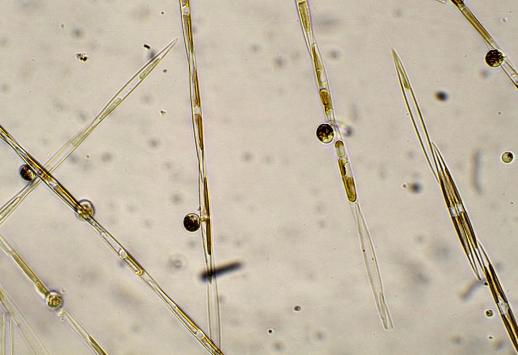
The bloom that began earlier this year and shut down several shellfish fisheries along the West Coast has grown into the largest and most severe in at least a decade.UW research analyst Anthony Odell left June 15 from Newport, Oregon, aboard the National Oceanic and Atmospheric Administration's research vessel Bell M. Shimada. He is part of a NOAA-led team of harmful algae experts who are surveying the extent of the patch and searching for "hot spots"—swirling eddies where previous research from the UW and NOAA shows the algae can grow and become toxic to marine animals and humans."The current bloom of Pseudo-nitzschia spp., the diatom responsible for domoic acid and amnesic shellfish poisoning, appears to be the biggest spatially we have ever observed," Odell said. "It has also lasted for an incredibly long time—months, instead of the usual week or two."Odell is the coastal sampling coordinator at the UW's Olympic Natural Resources Center in Forks, Washington, part of the UW College of the Environment. From his base in Hoquiam, Odell samples shellfish, phytoplankton and water quality, and responds to toxic algae bloom events along Washington's outer coast.Now he is doing toxin sampling on the three-week first leg of the NOAA voyage, from San Diego to San Francisco. Three more legs will continue through mid-September, surveying up to the north end of Vancouver Island.The first samples collected from near San Diego were fairly clean, Odell said, suggesting they were still south of the patch. More recent samples collected this week from near Santa Barbara showed the first signs of the harmful algae. The massive bloom is known to extend at least from central California to Vancouver Island, with reports coming from as far north as Alaska.As the ship travels north it is making a large back-and-forth grid, sampling the water from very near shore to several miles offshore. NOAA scientists initially scheduled the cruise to survey sardine and hake. Researchers from the UW, NOAA and other partners were invited to join and use the opportunity to conduct a large-scale sampling for marine toxins.The bloom includes some of the highest toxin levels ever recorded in Monterey Bay, California, and along the central Oregon coast. All of Washington's razor clamming beaches are currently closed, and the southern coast of Washington has the largest-ever closure of our state's Dungeness crab fishery.For the past 12 years, Odell has been a research analyst for the UW-led Olympic Region Harmful Algal Bloom Partnership. The organization provides monitoring data and other information about toxic algae blooms to coastal communities on Washington's Olympic Peninsula.The UW's Washington Sea Grant is involved in a similar monitoring effort for Puget Sound, SoundToxins, which has some 50 volunteers monitor 33 sites weekly throughout the sound.The massive bloom that emerged this spring comes after a few relatively quiet years. While the phenomenon is natural and cannot be prevented, better knowledge could help to predict and prepare for its effects.In recent years, UW oceanographers including Barbara Hickey and Ryan McCabe sampled coastal waters to help identify the origin of toxic Pseudo-nitzschia cells on the Washington and Oregon coasts. The studies resulted in the development of computer models that can simulate how the blooms travel.
Researchers pinpoint massive harmful algal bloomComputer-based forecasts rely on continuous observations from onshore sampling efforts and offshore buoys. A regional ocean-observing data portal led by Jan Newton, an oceanographer at the UW Applied Physics Laboratory, combines water observations from federal, state and other agencies and provides that information and some forecasts to users in real time."Such observations are critical to understanding what new elements in the coastal ocean produced such a massive toxic bloom this year, and whether we should expect these conditions to continue," Hickey said.The main culprit for the current toxicity is Pseudo-nitzschia, a tiny algae that under certain conditions releases an acid that acts as a neurotoxin. On campus, UW oceanographers are using genetic tools to better understand these microscopic creatures and learn how they respond to changing conditions.What caused the current bloom remains a mystery. Nick Bond, a research meteorologist at the UW Joint Institute for the Study of the Atmosphere and Ocean, coined the term "the blob" for the current huge patch of unusually warm water off the West Coast, and has studied its origins. Whether warm water is connected to the algal bloom is unknown."Our goal is to try to put this story together once we have data from the cruises," Vera Trainer, a NOAA scientist and UW affiliate professor of aquatic and fisheries sciences, told the Seattle Times. She manages the Harmful Algal Blooms Program at NOAA's Northwest Fisheries Science Center and is overseeing the current sampling effort.
Subscribe to seafoodnews.com
Letters: Grossman Article on Reasons for Sardine Decline Inaccurate
— Posted with permission of SEAFOODNEWS.COM. Please do not republish without their permission. —
SEAFOODNEWS.COM [Letters] - June 23, 2015Editor’s Note: The following letter from D.B. Pleschner was reviewed and supported by Mike Okoniewski of Pacific Seafoods.To the Editor: I take exception to your statement: "The author of this piece, Elizabeth Grossman, buys into the argument, but in a fair article.”In no way was this “fair” reporting. She selectively quotes (essentially misquotes) both Mike Okoniewski and me (and this after I spent more than an hour with her on the phone, and shared with her the statements of Ray Hilborn, assessment author Kevin Hill and other noted scientists.) She does not balance the article but rather fails to emphasize the NOAA best science in favor of the Demer-Zwolinski paper, published in NAS by NOAA scientists who did not follow protocol for internal review before submitting to NAS (which would have caught many misstatements before they saw print).NOAA’s Alec MacCall later printed a clarification (in essence a rebuttal) in NAS, which pointed out the errors and stated that the conclusions in the Demer paper were “one man’s opinion”.Oceana especially has widely touted that paper, notwithstanding the fact that the SWFSC Center Director also needed to testify before the PFMC twice, stating that the paper’s findings did not represent NOAA’s scientific thinking.After the Oceana brouhaha following the sardine fishery closure, NOAA Assistant Administrator Eileen Sobeck issued a statement. SWFSC Director Cisco Werner wrote to us in response to our request to submit Eileen’s statement to the Yale and Food & Environment Reporting Network to set the record straight:“The statement from the NMFS Assistant Administrator (Eileen Sobeck) was clear about what the agency's best science has put forward regarding the decline in the Pacific Sardine population. Namely, without continued successful recruitment, the population of any spp. will decline - irrespective of imposed management strategies.”It is also important to note that we are working closely with the SWFSC and have worked collaboratively whenever possible.I would greatly appreciate it if you would again post Sobeck’s statement to counter the inaccurate implications and misstatements in Elizabeth Grossman’s piece.Diane Pleschner-SteeleCalifornia Wet Fish Producers AssociationPS: I also informed Elizabeth Grossman when we talked that our coastal waters are now teeming with both sardines and anchovy, which the scientific surveys have been unable to document because the research ships survey offshore and the fish are inshore.Sobeck’s statement follows:Researchers, Managers, and Industry Saw This Coming: Boom-Bust Cycle Is Not a New Scenario for Pacific SardinesA Message from Eileen Sobeck, Head of NOAA FisheriesApri 23, 2015Pacific sardines have a long and storied history in the United States. These pint-size powerhouses of the ocean have been -- on and off -- one of our most abundant fisheries. They support the larger ecosystem as a food source for other marine creatures, and they support a valuable commercial fishery.When conditions are good, this small, highly productive species multiplies quickly. It can also decline sharply at other times, even in the absence of fishing. So it is known for wide swings in its population.Recently, NOAA Fisheries and the Pacific Fishery Management Council received scientific information as a part of the ongoing study and annual assessment of this species. This information showed the sardine population had continued to decline.It was not a surprise. Scientists, the Council, NOAA, and the industry were all aware of the downward trend over the past several years and have been following it carefully. Last week, the Council urged us to close the directed fishery on sardines for the 2015 fishing season. NOAA Fisheries is also closing the fishery now for the remainder of the current fishing season to ensure the quota is not exceeded.While these closures affect the fishing community, they also provide an example of our effective, dynamic fishery management process in action. Sardine fisheries management is designed around the natural variability of the species and its role in the ecosystem as forage for other species. It is driven by science and data, and catch levels are set far below levels needed to prevent overfishing.In addition, a precautionary measure is built into sardine management to stop directed fishing when the population falls below 150,000 metric tons. The 2015 stock assessment resulted in a population estimate of 97,000 metric tons, below the fishing cutoff, thereby triggering the Council action.The sardine population is presently not overfished and overfishing is not occurring. However, the continued lack of recruitment of young fish into the stock in the past few years would have decreased the population, even without fishing pressure. So, these closures were a “controlled landing”. We saw where this stock was heading several years ago and everyone was monitoring the situation closely.This decline is a part of the natural cycle in the marine environment. And if there is a new piece to this puzzle -- such as climate change -- we will continue to work closely with our partners in the scientific and management communities, the industry, and fishermen to address it. Read/Download Elizabeth Grossman's article: Some Scientists and NGO’s Argue West Coast Sardine Closure was too Late
Subscribe to seafoodnews.com
Toxic algae bloom might be largest ever
Scientists onboard a NOAA research vessel are beginning a survey of what could be the largest toxic algae bloom ever recorded off the West Coast.
A team of federal biologists set out from Oregon Monday to survey what could be the largest toxic algae bloom ever recorded off the West Coast.The effects stretch from Central California to British Columbia, and possibly as far north as Alaska. Dangerous levels of the natural toxin domoic acid have shut down recreational and commercial shellfish harvests in Washington, Oregon and California this spring, including the lucrative Dungeness crab fishery off Washington’s southern coast and the state’s popular razor-clam season.At the same time, two other types of toxins rarely seen in combination are turning up in shellfish in Puget Sound and along the Washington coast, said Vera Trainer, manager of the Marine Microbes and Toxins Programs at the Northwest Fisheries Science Center in Seattle.“The fact that we’re seeing multiple toxins at the same time, we’re seeing high levels of domoic acid, and we’re seeing a coastwide bloom — those are indications that this is unprecedented,” Trainer said.Scientists suspect this year’s unseasonably high temperatures are playing a role, along with “the blob” — a vast pool of unusually warm water that blossomed in the northeastern Pacific late last year. The blob has morphed since then, but offshore waters are still about two degrees warmer than normal, said University of Washington climate scientist Nick Bond, who coined the blob nickname.“This is perfect plankton-growing weather,” said Dan Ayres, coastal shellfish manager for the Washington Department of Fish and Wildlife.Domoic-acid outbreaks aren’t unusual in the fall, particularly in razor clams, Ayres said. But the toxin has never hit so hard in the spring, or required such widespread closures for crabs.“This is new territory for us,” Ayres said. “We’ve never had to close essentially half our coast.”Heat is not the only factor spurring the proliferation of the marine algae that produce the toxins, Trainer said. They also need a rich supply of nutrients, along with the right currents to carry them close to shore.Scientists onboard the NOAA research vessel Bell M. Shimada will collect water and algae samples, measure water temperatures and also test fish like sardines and anchovies that feed on plankton. The algae studies are being integrated with the ship’s prime mission, which is to assess West Coast sardine and hake populations.The ship will sample from the Mexican border to Vancouver Island in four separate legs.“By collecting data over the full West Coast with one ship, we will have a much better idea of where the bloom is, what is causing it, and why this year,” University of California, Santa Cruz ocean scientist Raphael Kudela said in an email.He and his colleagues found domoic-acid concentrations in California anchovies this year as high as any ever measured. “We haven’t seen a bloom that is this toxic in 15 years,” he wrote. “This is possibly the largest event spatially that we’ve ever recorded.”On Washington’s Long Beach Peninsula, Ayres recently spotted a sea lion wracked by seizures typical of domoic-acid poisoning. The animal arched its neck repeatedly, then collapsed into a fetal position and quivered. “Clearly something neurological was going on,” he said.Wildlife officials euthanized the creature and collected fecal samples that confirmed it had eaten prey — probably small fish — that in turn had fed on the toxic algae.Ayres’ crews collect water and shellfish samples from around the state, many of which are analyzed at the Washington Department of Health laboratory in Seattle. DOH also tests commercially harvested shellfish, so consumers can be confident that anything they buy in a market is safe to eat, said Jerry Borchert, the state’s marine biotoxin coordinator.But for recreational shellfish fans, the situation has been fraught this year even inside Puget Sound.“It all really started early this year,” Borchert said.Domoic-acid contamination is rare in Puget Sound, but several beds have been closed this year because of the presence of the toxin that causes paralytic shellfish poisoning (PSP) and a relatively new threat called diarrhetic shellfish poisoning (DSP). The first confirmed case of DSP poisoning in the United States occurred in 2011 in a family that ate mussels from Sequim Bay on the Olympic Peninsula, Borchert said.But 2015 is the first time regulators have detected dangerous levels of PSP, DSP and domoic acid in the state at the same time — and in some cases, in the same places, he said. “This has been a really bad year overall for biotoxins.”Over the past decade, Trainer and her colleagues have been working on models to help forecast biotoxin outbreaks in the same way meteorologists forecast long-term weather patterns, like El Niño. They’re also trying to figure out whether future climate change is likely to bring more frequent problems.At a recent conference in Sweden on that very question, everyone agreed that “climate change, including warmer temperatures, changes in wind patterns, ocean acidification, and other factors will influence harmful algal blooms,” Kudela wrote. “But we also agreed we don’t really have the data yet to test those hypotheses.”On past research voyages, Trainer and her team discovered offshore hot spots that seem to be the initiation points for outbreaks. There’s one in the so-called Juan de Fuca Eddy, where the California current collides with currents flowing from the Strait of Juan de Fuca. Another is Heceta Bank, a shallow, productive fishing ground off the Oregon coast, where nutrient-rich water wells up from the deep.“These hot spots are sort of like crockpots, where the algal cells can grow and get nutrients and just stew,” Trainer said.Scientists have also unraveled the way currents can sweep algae from the crockpots to the shore. “But what we still don’t know is why are these hot spots hotter in certain years than others,” Trainer said. “Our goal is to try to put this story together once we have data from the cruises.”
Read the original post: http://www.seattletimes.com