‘The Blob’ Fueling Drastic Changes Under The Sea Ahead Of El Niño
It’s the crack of dawn on a recent morning at Fisherman’s Landing in Point Loma, and the docks are bustling.Dozens of enthusiastic anglers have just returned with a boatload of bluefin tuna, dorado and yellowtail.It’s been a banner season, said Andrew Dalo, who books reservations for Point Loma Sportfishing.“I’ve got overnight and day-and-a-half boats that are catching 100- to almost 200-pound bluefin tuna up off our coast here, out west and up north," Dalo said. "And that’s stuff that we don’t even normally see up here, let alone go after."

Point Loma Sportfishing - A group of anglers on a Point Loma Sportfishing expedition pose with their bluefin tuna catches, weighing 100 to 200 pounds each, July 29, 2015.
The tropical fish are typically reeled in off Mexico and far off-shore, Dalo said. Now they’re being hooked as close as 10-20 miles off of San Diego, where water temperatures are exceptionally warm.“Right now we’re 4 to 5 degrees above normal, which to you and me doesn’t seem like much, but if you’re an animal living in the sea and you live at that temperature — that’s a huge change,” said Toby Garfield, director of the Environmental Research Division at Southwest Fisheries Science Center in La Jolla.The warm water, which scientists have named “the blob,” formed two years ago near Alaska and has spread down the West Coast. Garfield said the warm conditions have sent mother nature into disarray.“In fact, having this additional warm water has changed the winds a little bit,” Garfield explained. “The upwelling winds really drive the productivity along the California coast. So if you reduce that productivity, you start changing a lot of different parts of the whole ecosystem.”Much of the fishery population has shifted north, and El Niño hasn’t even arrived yet, said Garfield, who analyzes ocean conditions and reports his findings to the Pacific Fishery Management Council."If you go out and do an assessment and you’re not sure where that population is from, you can get some erroneous results in terms of how you’re going to divide up the fisheries," Garfield said. "And remember, the fish don’t know there’s a Mexican border or Canadian border."“We really do have a front row seat on a fascinating change,” Garfield added. “We haven’t seen it this anomalously warm in the record, and at the same time, we’re having a developing El Niño.”Garfield said he sees two possible scenarios playing out this winter: El Niño's storm energy will stir up the water, causing the cool water from the ocean depths to mix with and cool the water at the surface.“That’s one scenario — that it may disappear and will go back to more normal temperatures,” Garfield explained. “The other scenario is that the two will reinforce each other and we’ll have even warmer conditions, and the weather patterns will be different than we expect with a normal El Niño.”Garfield says additional heat from El Niño could produce storms with higher energy and moisture.Meanwhile, the telltale signs of current ocean water temperatures from “the blob” have appeared in recent months along San Diego’s shores. The unusual visitors range from hammerhead sharks to tropical fish to millions of red tuna crabs.“We’ve also seen 'by the wind sailors' that have occurred en masse on the shores here on La Jolla and elsewhere,” said David Checkley, a professor of marine biology at Scripps Institution of Oceanography.Checkley said the reduction in upwelling of cold water nutrients from the ocean floor has drastically altered the food web.“At the base of the food chain it’s been observed that the amount of chlorophyll or phytoplankton is lower than normal because we have fewer nutrients brought up into the surface waters,” Checkley said.Phytoplankton provide food for a wide range of sea creatures including whales, shrimp, snails, and jellyfish, according to the National Oceanic Atmospheric Administration.“The continued poor health of the California sea lion population is likely due to a lack of forage — anchovy, sardines... perhaps squid,” Checkley said.An algal bloom occurring along the West Coast from California up to Alaska is also a growing concern.“Those harmful algal blooms sometimes come with toxins — demoic acid that can poison marine mammals that eat fish that consume those algae," he said.Checkley said water temperatures will likely eventually return to normal, but he can’t help but look at the conditions as a harbinger of the future.“What perhaps is worrisome is if you think of things such as this and a long-term trend in a rise in temperatures associated with the climate warming or climate change,” Checkley said.He predicts some sea creatures will suffer through El Niño.“The winners are the recreational fishermen,” Checkley said.San Diego's sportfishing season usually wraps up in September, but not this year.
“We’re hoping this stuff stays around,” Dalo said. “If it stays up here, we can fish in U.S. waters. You bet. We’ll fish into October. We’ll fish into November.”


NASA - This map of the West Coast shows sea surface temperature anomalies in the Pacific Ocean in March 2015. They show how much above (red) or below (blue) water temperatures were compared to the long-term average from 2003 to 2012.
 By Susan Murphy - Tuna crabs blanket the shoreline at Ocean Beach in San Diego, June 12, 2015.
Read the original post and watch the video: www.kpbs.org
Monterey Bay fishermen secure $1M in fishing rights
 The bright afternoon sun beats down on a fisherman as he casts his line off the Santa Cruz Municipal Wharf on Tuesday. (Kevin Johnson -- Santa Cruz Sentinel)
MONTEREY >> A big benefit for the local community, Monterey Bay anglers now will have permanent access to more than $1 million in commercial groundfish fishing quota thanks to a recent acquisition by the Monterey Bay Fish Trust.“Oftentimes, it is extremely difficult to get quota,” said Giuseppe Pennisi, a local commercial fisherman. “Having access to quota is the only way that we can fish consistently.”West Coast groundfish numbers have struggled for years, and so have the livelihoods of many fishermen with it. More than a decade after the federal government declared the groundfish fishery a disaster, new regulations rolled out to help the fish and fishermen rebound.Since 2011, the fishery has been subject to a “catch share” system. Now fisherman no longer have to race against one another, trying to catch as many fish as possible before the entire fishery’s quota is reached. Instead, they’re allotted a share of the quota and can fish at their own speed.The program, which is highly regulated and includes a bycatch quota as well, has been successful in terms of conservation. In 2014, the Monterey Bay Aquarium’s Seafood Watch program upgraded 21 groundfish species from the “avoid” list to “good alterative” or “best choice.”But a concern of the “catch share” system is that fisherman can sell their quota allocations on the open market to the highest bidder. It leaves smaller fishing communities like the Monterey Bay in jeopardy of losing out to bigger markets and businesses in the Pacific Northwest that have more money to buy the quota shares.“The big fish companies hoard their fishing quotas, which then become unavailable to independent fishermen,” Pennisi said.To protect local fishing businesses, the Monterey Bay Fisheries Trust was created to manage and lease groundfish quota to fishermen here, while working to improve the economic and environmental aspects of the fishery.The nonprofit secured the $1 million in fishing rights from the Nature Conservancy, which purchased quota shares from willing sellers to lease them back to local fisherman who operate more sustainably before the “catch share” system — and a cap on the amount of shares any individual or entity can hold — was implemented. So the Nature Conservancy has been divesting shares to local community organizations focused on conservation as well.“Now local fishermen will know that they have access to this supply of quota, they don’t have to compete for it on the open market and they don’t have to compete with bigger businesses,” said Sherry Flumerfelt, executive director of Monterey Bay Fisheries Trust.The acquisition equates to about 4.2 million pounds of different groundfish species, including sable fish, rockfish and petrale sole. Though the amount is a major boost for Monterey Bay fishing industry, commercial fishers still can’t afford all the quota shares they need.“It sounds like an awful lot and it’s a good start, but it’s not enough,” Flumerfelt said. “We’re looking to buy more.”Last month, the Monterey City Council allocated $225,000 to purchase additional groundfish quota.Monterey Bay fishermen need an estimated 6 million to 10 million pounds worth of quota to maintain a sustainable economy. However, it’s a tricky number to pin down because some species of groundfish are worth more than others.
Read the original post: www.santacruzsentinel.com/
Zeke Grader, Lifetime Advocate for Fish and Fishermen, Died at 68
 Zeke Grader, who was born into the fishing industry, spent a lifetime representing fishermen and was a staunch advocate for sustainable seafood, died Monday of pancreatic cancer at a San Francisco hospice. The longtime Sausalito resident was 68.For almost 40 years, Mr. Grader served as executive director of the Pacific Coast Federation of Fishermen’s Associations, the largest trade group of commercial fishermen on the West Coast. He retired this summer. Since 1992, he had also been executive director of the Institute for Fisheries Resources.“There are a lot of guys who would say that there wouldn’t have been any small boat commercial salmon fishermen for 20 years at least if not for Zeke Grader,” said Tim Sloane, who took over Grader’s post as head of the Federation of Fishermen’s Associations. “He built bridges between fishermen, policy folks, environmentalists and the scientific community. His ability to unite people around preserving the fisheries was unmatched.”The son of a Fort Bragg fish broker, Mr. Grader was an early advocate of seafood sustainability, and was particularly passionate about protecting wild salmon.“I think it was not so much a conscious decision of wanting to be a conservationist or an environmentalist; it was simply an economic necessity,” he once said in an interview with the Seafood Choices Alliance. “It was pretty clear to myself and a number of others that it didn’t matter what government or others did. If you didn’t have fish, you didn’t have fishing.”At a tribute to Mr. Grader at the Bay Model in Sausalito in April, Rep. Jared Huffman recalled Mr. Grader’s 2009 appearance on Sean Hannity’s conservative Fox News show. Hannity argued on behalf of government-subsidized fish farmers while Mr. Grader spoke forcefully for North Coast commercial fishermen.“Sean Hannity barely got a word in,” Huffman told the amused gathering.The congressman also commended Mr. Grader for helping stop the expansion of offshore oil drilling on the North Coast and for his role in the legal action to restore the San Joaquin River.Former congressman and secretary of state Leon Panetta spoke in a video tribute. In his blog, Lee Crockett of the Pew Charitable Trust quoted Panetta as saying, “If our oceans are the salt in our veins, Zeke Grader is the fire in our spirit.”Environmental journalist Dan Bacher wrote in the liberal political blog the Daily Kos that Mr. Grader “was one of the most quotable and witty people I’ve ever met.” He recalled his trenchant response to a 2006 federal government attempt to close the North Coast salmon season, ostensibly to protect the Klamath River.Bacher wrote:“Zeke pointed out that without efforts to address the root causes of the salmon fishery’s decline, ‘Putting fish back into a river that’s killing them makes as much sense as tossing virgins into a volcano.”Mr. Grader’s wife of 40 years, Sausalito attorney Lois Prentice, said that her husband was tireless in his efforts to protect the world’s oceans and rivers. Before he became ill, she said, “He was working on forming a worldwide organization for fisheries, to fight for clean water and against pollution. As a result, it would have a lot of clout and get a lot more done.”A Marine Corps veteran, Mr. Grader was a graduate of Sonoma State University and earned a law degree from the University of San Francisco.In addition to his wife, he is survived by his mother, Geraldine Grader of Fort Bragg, sisters Allison Grader of Reston, Virginia, and Lindsay Grader of Sacramento, and a brother, Samuel Grader of Fort Bragg.A memorial is being planned.
Restaurants Begin Pilot Program Dock to Dish in Southern California
— Posted with permission of SEAFOODNEWS.COM. Please do not republish without their permission. —
Copyright © 2015 Seafoodnews.com


Nearly 100 pounds of gleaming, fresh-caught California yellowtail and white sea bass arrived at Chef Michael Cimarusti's Los Angeles-based restaurant Providence on Wednesday morning. But this wasn't just another ho-hum seafood delivery.The pile of fish marks an important step toward a fundamentally different way that prominent chefs are beginning to source American seafood: the restaurant-supported fishery.Call it an evolutionary leap from community-supported-
Subscribe to SeafoodNews.com 1-781-861-1441John Sackton, Editor and Publisher
El Niño, explained: Why this year's could be one of the strongest on record

Over the past year, scientists have been keeping a close eye on an important swath of the Pacific Ocean, just along the equator. When conditions here are just right, an El Niño can form — and wreak havoc on weather patterns across the globe.And right now, it looks like we're on pace for a very large El Niño this fall or winter. Quite possibly one of the strongest on record. Based on past experience, that could potentially bring much-needed rain in California, but also drought in Australia, destructive floods in Peru, and so on. A strong El Niño could also help make 2015 and 2016 some of the hottest years ever recorded. It'd be a very big deal.But El Niño events are often unpredictable and full of surprises. So nothing's guaranteed just yet. What follows is a guide to how El Niño works, what we know about the 2015 event, and how a potentially massive El Niño could upend the world's weather later this year.
A very basic definition of El Niño
- El Niño is a weather phenomenon that occurs irregularly in the eastern tropical Pacific every two to seven years. When the trade winds that usually blow from east to west weaken, sea surface temperatures start rising, setting off a chain of weather impacts.
- El Niños can be strong or weak. Strong events can temporarily disrupt weather patterns around the world, typically making certain regions wetter (Peru or California, say) and others drier (Southeast Asia). Some countries suffer major damage as a result.
- El Niños also transfer heat stored in the deeper layers of the ocean to the surface. When combined with global warming, that can lead to record hot years, as in 1998.
- "El Niño" got its name in the 1800s from Peruvian fisherman, who first noticed a mysterious warm current that would appear around Christmas. They called it the "little boy" or "Christ child."
Why this year's El Niño could be a huge deal
The last truly massive El Niño appeared in 1997-'98 and ended up causing an estimated $35 billion in destruction and 23,000 deaths around the world. (It also inspired that famous Chris Farley sketch.) Now we may be on the verge of a similar-size event:

Early-August status of the 1997 and 2015 El NIño events. Satellite imagery shows the departure from average sea-surface height for a given time of year, which is correlated with warmth in the upper ocean. (NASA/JPL via Weather Underground)
That, in itself, is a surprise. Back in March, NOAA's Climate Prediction Center announced that a weak El Niño had formed in the Pacific, but many experts initially thought it might just fizzle out in the summer. Instead, El Niño kept getting stronger, with ocean temperatures in the eastern tropical Pacific continuing to soar. Some forecasters now think this could turn into one of the strongest El Niño events in memory when it peaks later this fall or winter."We’re predicting this El Niño could be among the strongest El Niños in the historical record, dating back to 1950," said Mike Halpert, deputy director of the Climate Prediction Center, in a recent press call. We'll see if this latest forecast holds up.If it does, countries across the globe will have to brace themselves. In the past, major El Niño events have brought unusually hot, dry weather to Australia that can cramp wheat yields and amp up wildfires. It can bring hotter, drier weather to India that hurts agriculture. It can bring heavy rain and destructive flooding to Peru, washing away houses and spreading cholera. In 1997, El Niño dried out Indonesia so badly that it led to huge forest fires whose smoke disrupted daily life in Singapore.Yet El Niño isn't all bad. In the United States, it could potentially bring needed rain this winter to ease California's drought (though also mudslides and flooding). Historically, El Niño has also served up milder US winters and helped tamp down hurricanes in the Atlantic Ocean.One important caveat here is that every El Niño is a bit different — and some have unexpected impacts. As NOAA's Emily Becker points out, strong El Niño events usually bring rain to California (as in 1982-'83), but occasionally they don't (as in 1965-'66):

Another story to watch is whether a strong El Niño could help make 2015 or 2016 the hottest year on record. This one seems increasingly plausible.Global temperatures are already going up over time, thanks to all the carbon dioxide we're adding to the atmosphere. According to NASA, 2014 was already the hottest year on record. But there was no El Niño that year — and El Niño years tend to be a bit hotter than average, as heat gets transferred from the ocean to the surface. So the combination of El Niño and rising CO2 could help 2015 and even 2016 break records:
(NOAA)
Bottom line: There's still a lot of uncertainty here, but El Niño could very well be the biggest weather story of late 2015, with potentially far-reaching impacts.
How El Niño actually works, step by step
To see how El Niño works, it helps to understand what the equatorial Pacific looks like under normal, or "neutral," conditions:1) Neutral conditions in the equatorial Pacific OceanNormally, the tropical Pacific features strong trade winds that blow warm ocean water from east to west, where it piles up near Indonesia. Meanwhile, back east along South America, frigid water deep down in the ocean gets pulled up closer to the surface, cooling the area around Peru. Here's a diagram:
(William Kessler/NOAA/PMEL)
As a result, during "neutral" conditions, sea levels are about half a meter higher near Indonesia than they are in Peru. And the surface water near Indonesia is about 8°C warmer (14.4°F) than it is near Peru. That temperature difference creates a convective loop in the atmosphere that, in turn, reinforces the trade winds.This ends up affecting a lot more than just this stretch of ocean. Because the Pacific is so vast, this system is a major driving force in the global climate. The large, warm pool of water near Indonesia causes the air above it to rise, creating rainfall in the region. And this system shapes the jet streams that guide weather and storms around the world.That's how it works under normal conditions, anyway. But things look a little different when El Niño comes along.2) Now along comes El NiñoEvery few years, those prevailing Pacific trade winds that blow east to west can weaken. (Scientists are still debating the nuances of exactly why this happens.)When the trade winds weaken, all that warm water that was piled up near Indonesia starts sloshing back eastward, pulled back down by gravity. What's more, the underwater layer known as the thermocline starts sinking. As a result, there's less cold water rising up from the deep ocean near South America — so the waters near Peru start warming up. Here's another diagram:
(William Kessler/NOAA/PMEL)
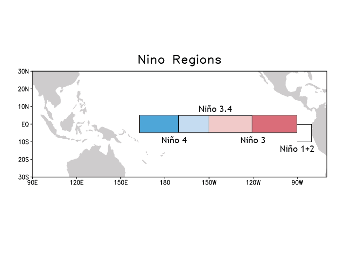
This causes sea surface temperatures in the east and central Pacific to start rising and the trade winds to weaken even further. What's more, rainfall starts following that warm pool of water as it travels eastward. That's why El Niño is usually associated with drier weather in places like Indonesia and Australia, as well as heavier rains in places like Peru (or California). The rain is essentially moving east.Scientists officially declare an El Niño when sea surface temperatures in the equatorial Pacific Ocean (known as the Niño 3.4 region) rise 0.5°C above their historical baseline for three months in a row — and once atmospheric conditions and rainfall patterns shift accordingly.Again, because the Pacific is so vast, an El Niño can have large ripple effects on weather around the world, especially during the winter months. Here's a look at the changes that have historically accompanied El Niño events:Typical effects of an El Niño during the winter:
(NOAA)
A strong El Niño can weaken monsoons in the Indian Ocean, for example. It can also cause the jet stream to start stretching from the Eastern Pacific across the southern United States, bringing rainfall and storms with it. Still, a lot depends on how strong the El Niño actually is — and occasionally there are aberrations and exceptions to the rule. More on that below.
El Niño's return in 2015 — and why scientists are talking about a "Godzilla" event
Ever since early 2014, scientists have been expecting this latest El Niño to form. But, in a sign of how slippery the system can be, El Niño kept defying predictions and not showing up.Finally, in March 2015, after a number of false starts, scientists at NOAA's climate prediction center were ready to declare that a weak El Niño was underway. Specifically, sea surface temperatures in that Niño 3.4 region (roughly in the center of the chart below) had been at least 0.5°C above their baseline since September. And, importantly, atmospheric conditions were responding in turn, with more rain over the central Pacific and less rain over Indonesia:
Sea surface temperature departures from average (based on 1981–2010) at the end of February 2015. NOAA map by Emily Becker, Climate Prediction Center.
At the time, however, NOAA's forecasters said that this El Niño looked "weak," with possibly minimal effects on global weather patterns, and only had a 50 to 60 percent chance of lasting through the summer.Then, somewhat unexpectedly, El Niño got stronger and stronger. By August 2015, sea surface temperatures had soared to more than 1.2°C above baseline in the Niño 3.4 region, and scientists were seeing the resulting telltale atmospheric changes. Here's a chart from July and August — notice how the anomalous warm area has moved eastward since March:

Sea surface temperatures in the tropical Pacific: departure from the 1981-2010 average. (NOAA)
NOAA's Climate Prediction Center is now estimating that there's a 90 percent chance El Niño will persist through the fall/winter. And when it peaks, signs suggest that this could be an extremely strong event, rivaling the strongest El Niños since detailed records began in 1950. Some forecasters have even dubbed this one a potential "Godzilla."Over at NOAA's ENSO blog, Emily Becker offers a more detailed breakdown of why forecasters are betting on a powerful, possibly record-setting, El Niño. Keep in mind that forecasts often go awry, that surprises occur regularly, and we can't be perfectly certain of how things will turn out. Still, she writes, "We have a relatively confident forecast for a strong event."
El Niño could bring rain to California — but may not end the drought
As noted above, El Niño tends to be associated with changes in weather patterns around the world, especially during the Northern Hemisphere winter. The most tantalizing possibility is that a strong El Niño could bring rain to California, potentially alleviating the state's drought.But even here, nothing is yet assured. El Niño only affects US weather indirectly, by altering atmospheric circulation and shifting the North Pacific jet stream. (See here for a lucid explanation by Columbia University's Anthony Barnston.) This is an intricate chain of events, and small kinks at certain points can affect the ultimate outcome.As such, Becker cautions people to think not in terms of certainties but in terms of probabilities. Here's an example of how El Niño might shift the odds of a wet winter for California (she notes that this isn't a prediction, just an illustration):
An example of how a strong El Niño could shift the odds for the amount of seasonal precipitation. Official outlooks from the Climate Prediction Center are available here.
In other words, thanks to El Niño, California has a greater chance of more precipitation this winter, but not a 100 percent chance.What's more, even if rain does come, that may not be enough to completely erase the massive water deficit that California has built up over the past five years. The state likely needs record precipitation to end the drought, and it also needs the right mix of rain (to recharge the reservoirs) and snow in the Sierra Nevada mountains (to melt during the spring and summer).Also, be warned: Heavy rain after a drought can bring floods and mudslides. So California needs to be ready for some negative impacts, as well.
El Niño tends to hurt some countries, and benefit others
It's not quite right to say that El Niño events are "bad" or "good." They tend to have different impacts on different regions.One recent study from the University of Cambridge found that on average, El Niño events hurt economic activity in Australia, Chile, Indonesia, India, Japan, New Zealand, and South Africa. The reasons varied: drought and reduced crop yields in Australia and India, forest fires in Indonesia, less-productive fisheries in Peru.But that study also found that on average, El Niño tends to boost the economies in Argentina, Canada, Mexico, and even the United States, at least in the very short term. Again, many factors were at play: In addition to bringing needed rain to California and Texas, El Niño was associated with less tornado activity in the Midwestern United States and fewer hurricanes in the Atlantic Ocean.Here's a table of the estimated economic impacts on a broad selection of countries:

Again, every big El Niño is different and has its own idiosyncrasies. So think of this table as more a rough guide than gospel.
El Niño could help make 2015 or 2016 the hottest years on record
Thanks to global warming, the Earth's average surface temperature has been going up over time. But there's a lot of variation from year to year. El Niño years tend to be a bit hotter than average. La Niña years (when those trade winds strengthen rather than weaken) tend to be a bit cooler than average. Like so:
(NASA)
So what's going on here? As humans load more greenhouse gases in the atmosphere, we're trapping more and more heat on the Earth's surface. But more than 90 percent of that extra heat is absorbed by the oceans. So subtle interactions between the ocean and the atmosphere can make a big difference for surface temperatures.When conditions in the Pacific are neutral, more of that heat is trapped beneath the ocean surface. When a strong El Niño forms, more of that heat is transferred to the surface. That's why the Earth's average surface temperatures reached new highs in 1998: you had the combination of global warming and an extremely strong El Niño.What was remarkable about 2014 is that it was likely the hottest year on record even without an El Niño event — a sign that Earth keeps getting warmer overall. Meanwhile, 2015 has so far been on track to be even hotter than 2014.Now throw a potentially record-setting El Niño into the mix, and we're looking at a potential shattering of records. Back in January, NASA's Gavin Schmidt explained at a press conference that temperatures typically peak about three months after an El Niño event. Given that forecasters expect this current El Niño to last until next spring, it's entirely possible we could see 2015 or 2016 break the temperature record. We'll have to wait and see.
Read the original post here: http://www.vox.com
5 Things We Learned From the 'Point of No Return' Climate Solutions AMA
Journalist Eric Holthaus and ten climate experts answered readers' questions about how to combat climate change

Eric Holthaus's recent Rolling Stone article, "The Point of No Return: Climate Change Nightmares Are Already Here," has clearly struck a chord, reaching millions of readers and advancing the conversation about the disastrous effects of our warming planet.One of the most common things people have asked after reading the piece is, "What can I do to help?" So on Thursday afternoon, Holthaus, along with ten climate experts, participated in a Reddit AMA to answer readers' questions about climate change solutions.Below are some of the things we learned.1. Climate experts aren't all doom and gloom; they're happy to offer solutions for "average" people."Teach your children to be mindful of what they do. That waste causes problems. That they live in the context of a big world but that the world is made up of individual actions," said marine ecologist Dr. Carl Safina."I would also add that 'awareness' is a key step forward. Talk about these issues with friends and families," said Kansas State University grasslands ecologist Dr. Jesse Nippert, adding, "Engagement with others also has more relevance when it's local – notice/record 'small things' in your community like changes in plant phenology (first flower, leaf drop), first freeze/thaw dates, rainfall amounts, etc….[C]itizen science has been a HUGE movement and source of invaluable data recording climate change.""Eat less meat. Choose low carbon transportation (basically anything but flying or driving in a car by yourself). Talk to your friends & family about [climate change]," added Holthaus.2. Some members of the public wish scientists would engage in more direct climate activism – and scientists have fascinating thoughts about that."I am a believer that we all have things to contribute, and we do not all have to do the same things to be effective," said Dr. Simone Alin, supervisory oceanographer at the NOAA Pacific Marine Environmental Laboratory. "I am glad people are marching in the streets to show how many people understand the problem and demand change. On the other hand, as a federal scientist, I have played a role in planning and implementing our regional, national, and international ocean acidification monitoring systems (with many, many great partners, from the policy world, academia, other gov't agencies, tribal nations, industry, NGOs, etc.). In this capacity, others in my organization/field and I have had the opportunity to present our scientific findings to all of the above partners, all the way up to Congress, which has resulted in many positive outcomes.""I think we benefit more from mutually supporting each other and realizing we can be partners at the same table than from suggesting others aren't doing enough because they are working through other channels," she said.3. The experts agree that modifying individual habits won't be enough to combat climate change – we need to see big changes at the government level too."We need both, to show our elected leaders we have skin in the game, but we need to demand that they take actions at the scale of their power," said J. Drake Hamilton, senior policy director at Fresh Energy. "I have heard Congressmen crow about switching a few light bulbs — they need to sign into law comprehensive, market-based systems that put a limit/price on carbon pollution and internalize those external costs of climate.""The problem is too huge for the citizens to be making bottom-up changes; it is almost an imperative from the state/country to be leading the way," said Dr. Nina Bednarsek, an ocean acidification scientist at the University of Washington and NOAA Pacific Marine Environmental Laboratory. "Having said that, citizens' responsibility is to try to make these changes on the local and state level by writing to their politicians and demanding more green approaches."4. Climate scientists have a sense of humor.When asked if the AMA participants had any "crazy ideas [for] promoting climate change," Dr. Alin responded, "A cooking show from the future. Premise: now that we only have jellyfish in our oceans, what tasty treats can we make out of them anyway?"She added, "More seriously, I have thought for a long time that we need some sort of mechanism/agency/organization to quantify the overall footprint of human actions on the environment….All of our consumption choices and actions (flying, driving) have a total environmental footprint, but I'm not aware of anyone or any organization that calculates this….Ideally it should be an international entity (UN I suppose) that would create evidence-based metrics to support the sustainability of various lifestyle choices and such. I say this in part as a consumer – it can be mind-boggling enough to go to the supermarket and pick out a cereal in our world of needlessly plentiful choices – how's a person to make important decisions about bigger consumption choices?"5. There is hope. Maybe.Asked if climate change is reversible, Dr. Bill Peterson, an oceanographer at the NOAA Northwest Fisheries Science Center, had this to say: "We can only hope."Holthaus followed up on Dr. Peterson's response, saying, "This is actually a pretty good answer from a scientific basis. There's no way of knowing if future technology will be able to reliably and affordably remove excess carbon dioxide from the atmosphere, so the best current approach is not to put it there in the first place."
Read the original post: www.rollingstone.com
Forget El Niño, the 'PDO' could be the real drought buster
 An image showing the positive / warm phase of a PDO and the negative / cold phase. The terms warm and cold refer to the temperature of water off the west coast of America. JPL/NASA
A new forecast out Thursday on the El Niño climate pattern shows it could be one of the strongest on record. And that could deliver much needed rain to Southern California and possibly northern parts of the state, too. But El Niños are usually fleeting, lasting only a year or two.Now, evidence is building that a longer-term climate pattern — one that might bring years of rainy winters — could be forming in the Pacific well north of the equatorial waters that give rise to El Niño.
The PDO game change
For the past several months, researchers have been tracking warmer temperatures in this northerly patch of ocean. And they're beginning to question whether we're about to see a switch in something called the Pacific Decadal Oscillation or PDO.Given the data, the PDO could be shifting from a cool phase to a warm one — a shift that could mean a wetter decade ahead for much of California. Still, the phenomenon could also turn out be a short-lived blip, not a years-long flip.Unlike El Niño, which focuses on sea surface temperatures in a stretch of the Pacific near the equator, the PDO looks at water in the northern part of the ocean, from Hawaii all the way to Alaska.According to research scientist Nathan Mantua with the National Oceanic and Atmospheric Administration, the PDO has a warm phase and a cool phase, and each one can last anywhere from a few years to decades.During the warm phase, waters along the coast of the western U.S. tend to heat up while the larger ocean about 200 miles off the coast cools down. During the cool phase these trends are reversed."When you have the warm pattern of the PDO, it tends to be wet in the southwest U.S. and northern Mexico," he explained.During those same years you are more likely to see drought in the Northern Rockies, Idaho, Eastern Washington, Western Montana and Southern British Columbia.Likewise, the cool phase is linked to wetter periods up north but dry conditions in Southern California and neighboring states.Mantua says the PDO has been mostly in a cool phase since 1998, coinciding with some of California's driest years on record.Climate scientist Bill Patzert with the Jet Propulsion Laboratory thinks it's this PDO pattern that is responsible in large part for the severe drought in the region.
Long-term drought buster on the horizon?
However, since January of 2014, the PDO has been shifting into a warm mode.Patzert thinks this could be the drought-buster the state has been hoping for."Perhaps in the long term, rooting for a [warm] PDO... is probably the most important thing for California and the American West," he said.Thursday and Friday at JPL's von Kármán Auditorium, Patzert will give a free public lecture on the PDO, El Niño and drought.He said even a strong El Niño isn't likely to supply all the water needed to get California out of a drought this bad.In fact, a recent NASA study found the state would need double the average rainfall in a single year to break the drought."In the long run these decadal or multi-decade variations in the Pacific are really the key to sustaining California agriculture and California civilization," Patzert said.That may be true for Southern California, but it is less clear how a warm PDO will affect Northern California, said NOAA's Nathan Mantua.That's because the northern part of the state is between the two regions that switch from wet and dry as the PDO shifts."Northern California sort of sits between the ends of this sort of north-south see-saw," he said.Still, he's optimistic that a warm PDO is coming, since the major index predicting this pattern has been positive for 19 months.But Mantua cautions that even such a strong signal can result in a warm PDO that only lasts a year or so."Beyond that, it's going depend on what the winds do and the weather patterns," he said.Sometimes those can change rapidly and dramatically, bringing drought conditions anew to California.Another wild card, according to JPL's Patzert, is how climate change will affect the PDO and related weather patterns."As we move into the 21st Century, climate is shifting beneath our feet... nobody really understands what the impact will be," he said.For now, climate watchers will keep their eyes on the ocean for signals of the weather to come.
Read/Listen to the original post: www.scpr.org