
RESEARCH IS THE KEY TO THE FUTURE - SARDINE RESEARCH PROJECT
Sardine Research Program
California sardine fishermen collaborate with scientists to improve knowledge of resource
In 2010, eight California sardine fishermen received special “exempted fishery” permits to catch sardines during closed season, continuing an innovative sardine research program co-sponsored by the California Wetfish Producers Association.
“The goal of this project is to document the volume of sardines extending from Canada to southern California to provide a coast-wide measure of sardine abundance,” says Diane Pleschner-Steele, Executive Director of CWPA. “Fishermen have brought their local knowledge to the project, and are working with scientists to expand knowledge of the resource and sardine migration, and to ensure a sustainable harvest.”
Scientists believe Pacific sardines begin spawning in Mexico and southern California and migrate northward in the summertime to feed; in favorable oceanic conditions fish may spawn multiple times enroute. A huge number of sardine schools, more than a million tons, have been reported in the Pacific Northwest during summer months in recent years. However, stock assessments for the past two years have declined sharply, and fishermen think the government-sponsored egg surveys, until 2009 the only index of abundance considered in annual assessments, did not account accurately for the enormous biomass of sardines observed in the Northwest.
In 2008 Pacific Northwest sardine interests contracted with scientists to develop an independent survey utilizing fishermen and spotter pilots, and a pilot project succeeded in photo-documenting an estimated 250,000 metric tons of sardines in a 91-mile area off the Columbia River in Oregon. The methods were reviewed and approved by a scientific panel appointed by the Pacific Fishery Management Council, which recommends management measures for coastal pelagic species, including sardine. In 2009 CWPA, representing California’s sardine industry, cooperated with the northwest sardine industry to apply for Experimental Fishing Permits from the Council and National Marine Fisheries Service. The goal was to expand the aerial survey into California as far south as Monterey. The survey took place in August through early September and, despite persistent foggy weather that limited visibility, the project succeeded: Scientists directing the project observed sardine schools on 18 of the 41 transects completed, and estimated the sardine biomass at 1.35 million metric tons in northern CA and the northwest.
Survey findings underwent more scientific scrutiny, and scientists applied a coefficient of .55 to account for uncertainty, but included the result in the 2009 stock assessment as a minimum estimate of absolute abundance. With aerial survey included, the assessment model predicted a spawning biomass of slightly more than 700,000 mt. After deducting 13 percent to account for Mexican catches and subtracting another 150,000 mt to account for forage for other marine life, the resulting harvest guideline provided 72,000 mt for harvest in 2010. Without the use of the aerial survey, the harvest guideline estimated from egg estimates alone would have virtually curtailed the fishery in 2010, inflicting an extreme negative impact on the wetfish industry and harbor communities.
Sardine Survey Methods
The industry-sponsored aerial survey operational plan specifies a two-step process:
Step 1 – spotter pilots fly predetermined aerial transects at a nominal height of 4,000 feet.
Transects are spaced 15 miles apart, and extend offshore.
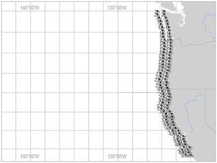
2009 Cape Flattery to Monterey Bay
Systematic Random Sampling Design
Sampling Unit = Transect
52 Transects, 35 miles in length, spaced 15 miles apart
Sophisticated digital camera systems mounted in the planes photograph the ocean surface with 60 percent overlap, recording any schools visible on the ocean surface.
Photos are enhanced on the computer in special Photoshop software and surface area of identified sardine schools is scientifically calculated.


Step 2 – under direction of spotter pilot and scientist in the field, purse seine vessels capture identified schools of specified sizes. Point set capture procedures are strict, and only fully-captured schools are counted.
Spotter pilots photograph the approach and capture process.

Fishermen maintain detailed logs, recording Latitude and Longitude of each individual point set, along with water temperature, height and depth of the school and estimated tonnage.
Each point set is stored in separate hatches on the vessel, and is weighed at the dock.
Biological samples are taken of each point set, and the recorded tonnage, along with biological data, are recorded for every point set captured.
Biological Sampling
Point Sets were sampled for:
n=50 fish/set, taken from unsorted catch at beginning, middle, and end of set
Length in mm
Weight accurate to 0.1 gm
Maturity male and female scales
Age (otoliths) 2/fish, 25 fish/set


The point set weights are linked to the photographs. Scientists have developed mathematical formulas to determine variance between and among schools, leading to a minimum estimate of sardine abundance.
Expanding on the 2009 survey, the Pacific coast survey this year consists of aerial transects flown at 15-mile intervals from Cape Flattery in Washington to southern California, extending 38 miles or more offshore: 26 transects in the Pacific Northwest, and 40 transects in California.
California is employing four experienced spotter pilots; each plane is equipped with a high-tech aerial camera system. In addition, eight purse seine vessels have agreed to participate: 4 operating in Monterey and northern CA, and 4 operating in southern CA.
This industry initiative has captured the attention of fishery managers nationwide, as well as scientists responsible for conducting sardine research on the west coast. Government scientists now voice interest in collaborating with industry to incorporate the aerial survey along with other scientific tools into a framework to improve future sardine stock assessments.
CWPA contracted with Dr. Doyle Hanan, retired senior marine biologist supervisor from Department of Fish and Game, to direct the California portion of this survey. “This is cutting edge fishery science and I’m delighted to be assisting in this project,” says Dr. Hanan. “I’m very hopeful that this program, which we intend to continue into the future, will lead to a new way to assess the abundance of sardines.”
“This survey will increase knowledge of the coast-wide sardine population and possibly also improve fishing opportunity,” CWPA Director Diane Pleschner-Steele explains. “California’s wetfish industry is very important to the culture and economic vitality of harbor communities in Monterey and southern California. “Our industry has always supported collaborative research to ensure sustainable fishery resources.”
The sardine harvest rule is the poster fish for ecosystem-based management; with a precautionary harvest quota that accounts for both oceanic conditions and sardines’ importance in the food chain. California sardines are considered a sustainable fishery, awarded a “best choice” green rating in the Monterey Bay Aquarium’s Seafood Watch list.